Monday
30th May
On the move again!
 |
| Motoring over to Spetses |
I had arranged to meet Kathleen on nearby Spetses where she would
arrive from Athens on the 10.15 Flying Dolphin Hydrofoil. Kathleen had flown back in from the UK
(Glasgow – Gatwick – Athens) yesterday and after staying the night at a hotel
in Piraeus she was coming west to join me much quicker than I had travelled
much of the same route on Saturday.

With Spetses being approx. 13 miles away an early start was in order
to allow sufficient time for me to find a berth for Tra Bhui and to get myself
to the pier in time for Kathleen’s arrival.
Rising earlier than normal and after having stowed the tent and made
a quick visit to the bakery in town to buy fresh bread and a couple of filled
pastries for breakfast and lunch, I raised Tra Bhui’s anchor at 6.50 hrs. to motor across to Spetses where I
arrived at 9.00 hrs., in plenty of time
to find a berth near the ferry pier and to have a look around before Kathleen
arrived.
 |
| Moored alongside in grander company |
The Flying Dolphin arrived just a few minutes late. I was glad to
see Kathleen disembark with the passengers who were getting of at Spetses, obviously
her travel arrangements had gone to plan.
Before going back to Tra Bhui we had time for a visit to a local
supermarket and for a coffee at a café / bar overlooking the harbour with the
parked water taxis moored just below us.
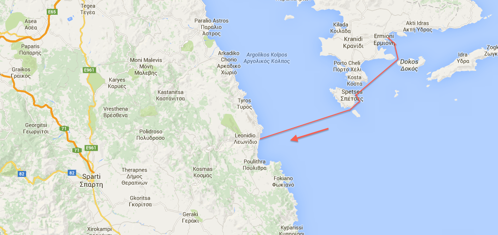
Leaving Spetses at 11.20 hrs. we headed around the south end of the
island before turning west across the Agrolic Gulf towards Leonidio where
planned to spend the night.
 |
| The crew is back on board |
With not a breath of wind we once again resorted to motoring the 13-mile
crossing. We had some excitement during the crossing when we met a small pod of
dolphins mid crossing. Despite stopping to watch them and then moving towards
them the dolphins were not inclined to come too near us.
 |
| Dolphins welcome Kathleen back! |
 |
| Approaching Leonidio |
The harbour at Leonidio is a few miles from the town itself which
has a prominent past in Greek history, but which is now mainly associated with
agriculture. Arriving just after 15.15 hrs. we moored alongside at the end of the concrete quay. The outer
wall of the quay had at some time in the past suffered significant storm damage
and lay toppled towards the sea. The construction of the wall was of very
obvious poor quality, but even still it must have taken a considerable sea to
dislodge it in this way.
 |
| Leonidio harbour with damaged sea wall |
 |
| Someone needs a shower after putting the tent up! |
After erecting the tent we walked around to the beach, which formed
the western edge of the harbour for a refreshing swim after which we briefly
explored the surrounding area but did not venture as far as the main town
itself.
 |
| Leonidio |
As it was a very hot day and with the sun still blazing overhead at
18.30 hrs. we retired to the terrace of one of the nearby bars for a drink and
to catch up on e-mails.
Miles today 28
Total Trip 357
Tuesday
31st May

 |
| The rugged Peloponnese Coast |
We were now on the Peloponnese
where the coastline changed back to the rugged rock lined base of the
mountain ranges that grew out of the ocean. Suitable harbours and places of
shelter were fewer and further apart and with the two main capes of Maleas and
Matapan (Tainaron) ahead of us we wanted to push on an make the most of the
current spell of good weather. Cape Maleas could be our biggest challenge yet
as the predominant NW-W winds would be contra to the slight tidal flow that
flows across the headland from east to west. If these conditions existed we
would face not only a potentially strong headwind, but also steep and
unpleasant seas.
When originally planning our Greek trip I had envisaged talking it
in four stages.
1.
Thessonaliki to Volos,
2.
Volos to Porto Khelli,
3.
Porto Khelli to Tripiti (north
west corner of the Peloponnese)
4.
And finally Tripiti to Igouminitsa,
which was the ferry, port that we arrived in Greece from Italy through.
But due to circumstances out with our control, i.e. the worldwide
drop in oil prices and the coming to an
end of my contract in Kazakhstan, I needed to be in a position that I could
take Tra Bhui back to the UK if required early in July should another
contract come along.
 |
| The coast passes slowly by |
This meant that as we were
already ahead of our original schedule after Kathleen’s visit back to
the UK, we revised our plans and now aim to have Tra Bhui in Lefkas by the 21st
of June as we both have to fly home for our son Scott’s graduation in Glasgow.
Therefore if the good weather held rather than follow the coastlines
of the Gulf of Lakonika (between Cape Maleas and Cape Matapan) and the Gulf of Messina (between Cape Matapan
and Cape Akritas) we could save on our mileage if we went straight from cape to
cape. As we were sailing against the
prevailing NW-W winds this would cut days from this part of our passage
Anyway back to our daily log:-
We departed Leonidio at 09.30 hrs. once again under motor as the
wind was a south westerly of variable strength ranging between 3 and 8
knots. Motoring continuously we reached
Yefira at 16.00 hrs. The wind briefly came in as we rounded the headland at
Yerakas going quickly from 8 knots to 29 knots but then dying away to almost
nothing 30 minutes later.
 |
| Lunchtime on board |
Yerifia is a small village and harbour situated at the landside end
of a stone causeway leading out to the island of Monemvasia
 |
We entered the town’s harbour behind a skippered charter yacht. With
the outer quays pretty full due to a number of yachts having tied up alongside
rather than going stern to we followed the skippered yacht into the inner basin
which being relatively small. The larger yacht in front of us was too big for
the available space and as it went astern we passed it and entered the inner
basin.
 |
| Traditional sailing ship alongside old quay in Yerifia |
Tra Bhui being an unusual vessel for these waters attracts attention
and soon a friendly French sailor was indicating that we should pull in behind
his yacht. Reluctant to occupy a space which may belong to a local fishing boat
we were surprised when a departing fishing boat also told us to use the space
being indicated to us. All very friendly
stuff.
 |
| Alongside |
For once we did not erect the tent. We planned an early start the
next morning and my ever-game crew agreed that we could forgo the tent even
though we were alongside in a fairly busy harbour.

With few domestic duties to do apart from lock any valuables away we
set out to find a cold drink or ice cream (in the end we had both), to find
fuel and to visit nearby Monemvasia
 |
The
island of Monemvasia was separated from the mainland by an earthquake in 375
AD. The majority of the island's area is a plateau about 100 metres above sea
level, and the town of the same name is built on the slope to the south-east of
the rock, overlooking Palaia Monemvasia bay. Many of the streets are narrow and
fit only for pedestrian and donkey traffic.

The
island, which is really just a extremely large rock, is thought to have been
settled as far back as the Minoan era as it is thought to have been the site of
a Minoan trading post. Pausanias, the renowned Greek traveler and geographer,
referred to the site as "Akra Minoa", which translates to
"Minoan Promontory"
The
town and fortress were founded in 583 by inhabitants of the mainland seeking
refuge from the Slavic and the Avaric invasion of Greece. A history of the
invasion and occupation of the Peloponnese was recorded in the medieval
Chronicle of Monemvasia.
From
the 10th century AD, the town developed into an important trade and maritime
centre. The fortress withstood the Arab and Norman invasions in 1147; farm
fields that fed up to 30 men were tilled inside the fortress. William II of
Villehardouin took it in 1248, on honourable terms, after three years of siege;
in 1259 William was captured by the Greeks after the battle of Pelagonia and in
1262 it was retroceded to Michael VIII Palaiologos as part of William's ransom.

It
remained part of the Byzantine Empire until 1460, becoming the seat of an imperial
governor, a landing place for Byzantine operations against the Franks, the main
port of shipment (if not always production) for Malmsey wine, and one of the
most dangerous lairs of corsairs in the Levant.
The
Emperors gave it valuable privileges, attracting Roger de Lluria who sacked the
lower town in 1292. The town welcomed the Catalan Company on its way eastward
in 1302. In 1397 the Despot of the Morea, Theodore I Palaiologos, deposed the
local dynast of Monemvasia, who appealed to Sultan Bayezid I and was reinstated
by Turkish troops.

In
1419 the rock appears to have come into the possession of Venice, though it
soon returned to the Despot. About 1401, the historian George Sphrantzes was
born in the town. After the fall of Constantinople in 1453 Monemvasia held out
against the threats of Sultan Mehmed II in 1458 and 1460, when it became the
only remaining domain of the Despot of the Morea, Thomas Palaiologos, claimant
of the Imperial throne. He had no forces to defend it; he offered it to the Sultan,
and finally sold it to the Pope.[4]
By
1464 the inhabitants found the Pope's representative feeble and the Pope unable
to protect them; they admitted a Venetian garrison. The town was fairly
prosperous under Venetian rule until the peace of 1502-3, in which it lost its
farm lands, source of its food supply and of Malmsey wine. The food had to come
by sea or from Turkish-held lands, and the cultivation of wine languished under
Turkish rule.

The
rock was governed by the Venetians until the treaty of 1540, which cost the
Republic Nauplia and Monemvasia, her last two possessions on mainland Greece.
Those inhabitants who did not wish to live under Turkish rule were given lands
elsewhere.[4] The Ottomans then ruled the town until the brief Venetian recovery
in 1690, then again from 1715 to 1821. It was known as "Menekşe"
("Violet" in Turkish) during Ottoman rule and was a sanjak (province)
centre in the Morea Eyalet.
The
commercial importance of the town continued until the Orlov Revolt (1770) in
the Russo-Turkish War, which saw its importance decline severely.
The
town was liberated from Ottoman rule on July 23, 1821 by Tzannetakis Grigorakis
who entered the town with his private army during the Greek War of
Independence.

In
1971, Monemvasia became linked with the rest of the outside world through a
bridge on the western side that replaced the earlier stone arch structures
Miles today 33
Total miles 390

Waking early I quickly stowed my sleeping bag and had cast off our
lines just before 05.00 hrs. Although still dark we planned a longer passage,
which with no wind forecast we knew would al be under motor. The crew chose to stay in bed and slept on
the floor boards on the opposite side of the cockpit for another two hours or
so awaking just in time to see some dolphins that again decided to keep their
distance from Tra Bhui


Subject to the actual weather we had two options 1) sail around Cape
Maleas and then stop at anchor behind the island of Elafonisos or 2) once we
had rounded the cape push on across the Gulf of Lakonika to Porto Kayio. As we
had good weather we decided to push on
 |
| Approaching Cape Matleas |
There is not a lot to say about the passage apart that just after
13.00 hrs. the arrived blowing a steady 18 knots from the south west. Although we could have raised some sail our
day had been long enough and the thought of setting our sails reefed to tack
the final 10 miles or so upwind did not hold much appeal. The wind did bring
steep and very wet seas causing a good deal of spray to come over Tra Bhui’s
gunwales.

 |
| Small church / place of worship set into cliff face |

We arrived in Porto Kayio at 15.50 hrs. having motored continuously
for nearly 11 hrs.
 |
| Approaching Porto Kayio |
Porto Kayio is a small village set aside a very sheltered lagoon on
the eastern side of the Mani Peninsula about three miles north of Cape Matapan,
the southernmost tip of the Mani Peninsula and of mainland Greece.
The
ancient name was Psamathous, mentioned by Pausanias. The modern name comes from
the Venetian Porto Quaglio and the French (Frankish) Port des Cailles (Quail
Port)
The
Ottomans built a castle here in about 1568, to protect the port, which was used
for galleys patrolling the Kythera Channel. The Venetians attacked the castle
in 1570, and the Ottomans surrendered and abandoned it.

In
1670, the Ottomans returned and built a new castle. They were driven out in
1770 during the Orlov Revolt. Porto Kagio was the base of Lambros Katsonis's
pirate fleet, and it was at Porto Kagio that it was finally destroyed. In World
War II, Porto Kagio was a place from where many British soldiers escaped to Egypt.

After setting Tra Bhui’s anchor I dropped over the side and swam
down to check that it had a good hold as although we were in a sheltered
harbour we were still being buffeted by rough gusts of wind.
Rowing ashore we found a bar with internet as I wanted to check the
forecast for the next few days. It looked as though our good weather was coming
to an end as the web sites we use for wind forecasts “Wind Guru” “Windfinder” “Poseidon”
(Greek forecast) and weather on line all forecasted strong south westerly winds
arriving around 14.00 hrs. the next day and lasting for the next 4 days or so.
 |
| Checking the anchor |
While we were pretty sheltered where we were we did not fancy 4 days
at anchor in Porto Kayio so we decided to review our option in the morning once
we had seen what the weather was doing outside the anchorage.
 |
| Waterproof sunglasses |
After a walk to see a little church at the mouth of the inlet, I
went back on board Tra Bhui to generally tidy her up and replenish the fuel
tank from the spare cans of fuel that we carry while Kathleen went for a walk
up a nearby hill.

We both met back on the shore an hour later and ate dinner at a
table on the beach outside one of the two restaurants in the small village.
Without the tent up we went to sleep below an amazing backdrop of
stars.
Miles today 52
Total miles 442

Waking early and with Kathleen still asleep I started the outboard
and raised the anchor allowing us to leave the anchorage at 05.05 hrs.
 |
| Approaching Cape Matapan |
The sea outside was like glass so I turned to starboard and headed
south towards Cape Matapan which is not only the most southerly point on
mainland Greece but is the second most southerly point in Europe. Later looking
at a map it was interesting to see that we were now as far south as southern
Turkey, further south than northern Syria, further south than most of Tunisia
and within sailing distance of Crete!
 |
| Just rounded Cape Matapan - the sun is rising behind us |
A mile or so outside the anchorage the outboard suddenly stopped!
Wakening Kathleen I unshipped our oars and started to row back towards the
mouth of the anchorage. Once we had sufficient sea room – the coastline there
is not someplace you want to go ashore – I looked for the source of the problem,
which sounded like fuel starvation. Sure enough I found that the main fuel line
between our oversized primary fuel filter / water trap and the engine had been
snagged when I put on one of the stern hatches. An easy fix!
With normal service resumed we made a few fast loops outside the
anchorage to make sure everything was OK and then resumed our passage.
Once around the headland we set a the Tiller Pilot on a heading that
would take us just inside the island of Venetiko some 37 miles away. In case
the weather started to deteriorate I had set a number of alternative
destinations as waypoints in the chart plotter, but if possible we wanted to
try and reach Finikunda a small resort town which would not only offer plenty
of shelter from the predicted winds, but where we were certain we could find
some onshore accommodation for a couple of nights.
The crossing simply followed a straight line from one point to
another. The wind stayed at around 8 knots from the South West until 12.00 hrs.
when it rose to about 14 knots still coming from the south west.
By 13.30 hrs. we had reached the shelter of Venetiko where I planned
to top up the fuel tank. Normally we can motor for approx. 50 miles or more on
a single tank, but we had been pushing on a bit faster than normal in order to stay ahead of the weather so I
wanted to make sure we were not about to run out. It was also time for lunch so I took the two
boxes containing food and plates out of the rear storage to pass to Kathleen in
anticipation of some tomato sandwiches.
No sooner had Kathleen opened the boxes than I was asking for them
back as I could see the wind filling in across the water ahead of us. As we passed inside Venetiko the wind quickly
rose to 25 knots with gusts of 29 knots. The sea, which had so far been fairly
calm quickly, became agitated as it only can in the Mediterranean. The wind
itself was not a problem as we had a powerful outboard and no sails up, but the
steep waves which rose to 3 feet or so quickly meant our passage became very
wet as we were constantly drenched in spray.
At this point we had the option to head for nearby Koroni which lay
in sheltered waters on our starboard beam, but we decided to continue on to
Finikunda as apart from the spray giving us a good soaking Tra Bhui was making
good way.
A mile later we ran out of fuel! Obviously we had burned our way
through a lot more than usual heading across the gulf. Refueling was pretty
quick as it is only a matter of opening one of the front deck hatches, opening
the tank lid and emptying another can of fuel into it. On Tra Bhui we have our fuel tank plumbed in
near the mast to keep weight forward. Although this means a longer than normal
fuel line, the use of oversized copper pipe and the ability to prime it with a
fuel bulb at the tank means that the outboard has fuel again almost
immediately.
The moral of this is -check the fuel before you make lunch!
As we approached Finikunda the wind died down and the seas
moderated until we had not much more
than a stiff breeze and a gentle swell.
We arrived in Finikunda at 14.40 hrs. after a passage of 47 miles (5
miles shorter than our passage on Wednesday) and 9.40 hrs. on the move.
The harbour at Finikunda is mainly for local fishing boats but we
found a space on the eastern breakwater just made for a Drascombe and anchored
stern to with the addition of some spring lines just in case the wind swung
round at all.
Once again I snorkeled down to make sure our anchor had set while
Kathleen dried out in the sunshine. With all the hatches locked we wandered
into town for a belated lunch and to use the internet to find some shore side
accommodation for the next few days while we waited for the weather system to
pass.
Using Booking.com we found a good deal for three nights
accommodation in fantastic accommodation just outside the village, so it was
back to Tra Bhui to collect our two barrels of clothes and two Peli cases with
our cameras and computers before we locked the hatches and put on her cockpit
cover in preparation for leaving her for a few days.
Miles Today 47
Total Miles 489