Sunday 10th July
Today
we simply travelled north, passing through Italy Austria, Switzerland and Germany
before reaching the campsite where we planned to stay in France. - 5 countries in one day - is there a song about that?
Apart
from some confusion when our Tom Tom started taking us south again – the Tom
Tom route took us south then west then north and we planned to go north then
west then north, our journey was pretty uneventful apart from when we (I) rejoined the
motorway heading in the wrong direction after having stopped for fuel in
Austria. This necessitated coming off, finding somewhere to turn and then rejoining
the motorway again – this time heading in the right direction!
Our
route took us north on the A22 Autostrada through the Brenner Pass into Austria
where the A22 became the A13. At Innsbruck
we turned west on to the A12 which we then followed until it changed to the S16
just west of Landek and then to the A14 at Bludenz.
Reaching
Dornbirn we turned south and crossed the border into Switzerland where we
followed Route 1 to Zurich and then Route 3 to Basel.
 |
| Just passing through |
Just
north of Basel we crossed in to Germany where we followed the A5 and then Route
31 to Breisach. At Breisach we crossed into France. The border with France is
demarked by the river Rhine.
We
had booked a pitch at Camping L'Ile du Rhin which as the name suggests was on
an island in the middle of the Rhine just a few yards into France.
We
had booked the campsite on the Internet again using the Pitchup site.
The
island on which the three hectares site was located was accessed from the main
road crossing the Rhine. The crossing was effectively formed by a bridge from
the island to either bank. On one side of the Rhine (east of the campsite) was
the German town of Breisach while just a mile or so away from the other bank of
the Rhine (west of the campsite) were the French towns of Volgelsheim and Algolsheim.
 |
| Camping L'Ile du Rhin |
Arriving
just after 18.00 hrs. we found the site reception closed, but we soon found a
member of staff at the site’s small bar / restaurant who booked us in and left
us to find a pitch.
 |
There
were many empty pitches set between overgrown hedges. The length of grass on
most pitches lead us to think that perhaps hay was being grown there. Two
circuits of the campsites small and tight roads allowed us to finally choose a
suitable pitch where the grass was short, toilets not too far away and where
Tra Bhui would fit in OK.
Roof
tent up, we set out to walk into Breisach on the German side of the Rhine to
find dinner.
 |
| Evening sets in in Breisach |
After
a wandering around and taking in the atmosphere we stopped for dinner at a
restaurant serving Italian / German food.
Monday 11th July
Having
spent all of Sunday in the car we decided that today would be a no driving day.
With Breisach just on the other side of
the river from the campsite (west bank) and the French towns of Volgelsheim and
Algolsheim only a mile or so away on the east bank we had plenty of exploring
that we could on foot.
The campsite
shop, so we had been told sold fresh bread every morning. Fresh French bread
sounded good so we were a bit surprised to find that only “bake off” bread was
on offer. Bake off bread is unfortunately becoming more and more common in UK
shops, but to find it in France!!!! The bread was not even baked well or rather
it had been baked a little too well! We left with two croissants and a
blackened wizened stick of what we hoped was edible bread.
Over
breakfast we speculated about the campsite. Placed on what must be an ideal
location on an island in the middle of the Rhine, well placed for German, Swiss and
French nationals and for other more exotic tourists (like the Scots) visiting
not only Breisach, but the nearby cities nearby Colmar, Strasbourg and Freiburg,
the site looked as though it was on the verge of going out of business. An air
of dilapidation hung over it due to the long unkempt grass, closed toilet
blocks (half were closed) and an obvious lack of maintenance.
Later
as when we were in the camp reception we asked how busy the site got. It
appears that they are busy at weekends and normally all summer, but the poor
weather this year had meant it was quieter than usual.
 |
| Straddling the border between Germany and France |
Anyway
we set out to see Breisach which was in easy walking distance of the campsite.
We stopped as I am sure many people do on the road bridge to take a photograph
of our feet spanning the border between France and Germany and to watch the
water that was coming through the barrage that was just upstream.
The
course of the Rhine has changed considerably over the years due to the
intervention of man.
In
1685, Louis XIV started a project to move the Upper Rhine, change its course
and drain the flood plain, in order to gain land. By 1840, the river had been
moved up to 1.5 kilometres (0.93 mi) to the east, taking territory away from
Baden. Around 1790, large parts of the Rhine Valley were deforested, creating
arable land, fields and pasture to feed the population.
The
Upper Rhine was straightened between 1817 and 1876 by Johann Gottfried Tulla
and changed from a relatively sluggish meandering river with major and many
smaller branches into a fast flowing stream flanked by embankments.
 |
| The barrage at Breisach |
The
length of the Upper Rhine was reduced by 81 kilometres (50 mi). which is when
you think about it a pretty big shortening!
The barrage
that we were looking at was built as part of the straightening of the Rhine and
its canalisation. Over the 180km stretch between Basel and Iffezheim), there
are 10 dams, providing with hydro power and equipped with large locks to allow
the passage of shipping.
Between
Basel and Breisach, the old river bed carries hardly any water; almost all
water is diverted through the Grand Canal d'Alsace on the French side, to
ensure safe shipping and hydro power generation around the clock.
 |
| One of the two massive locks that barges used to bypass the barrage |
Only
in times of flood will the old river bed will receive more water than the
canal.
France
gained the right to do this in the 1919 Treaty of Versailles; the right applies
to the segment between Basle and Neuburgweier/Lauterbourg, where the Rhine
forms the border between France and Germany.
The
straightening (1817–76) and channelling (1928–77) has resulted in the water
table being reduced by up to 16m (52 ft)
which has not only changed the countryside around the Rhine, but which has
influenced the development of riverside town such as Breisach.
 |
| The cathedral from the south |
A
stop at a very goof German coffee and cake shop gave us the chance to read up a
bit more about Breisach in tour outdated guidebook before we set forth to
explore.
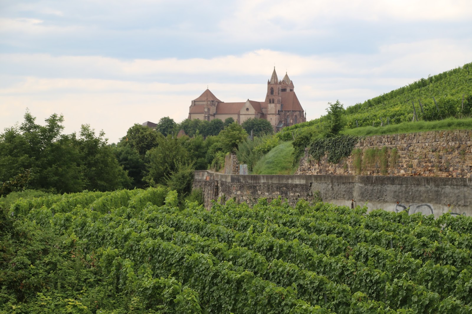
Breisach
(formerly Altbreisach) comes from Celtic and means breakwater. Knowing how much
the level of the Rhine had dropped over the last few hundred years meant that
this name made more sense to us as the hill on which the old town stands was
once surrounded by the river and marshes.
The
earliest settlers were thought to be the Celts and small settlement on the hill
was possibly the seat of a Celtic prince. The Romans followed the Celts and
they built a fort or castle there.
Habitation
continued over the centuries but it was not until the 13th century that the
town of Breisach really came to be when the construction on the St
Stephansmünster, the cathedral in Breisach, was started.
 |
| Radbrunnent Tower |
In
the early 16th century, Breisach was a significant stronghold of the Holy Roman
Empire. On December 7, 1638, Bernhard of Saxe-Weimar, who was subsidised by
France, conquered the city, which Ferdinand II and General Hans Heinrich IX.
von Reinach had defended well, and tried to make the centre of a new territory.
After Bernhard's death in 1639, his general gave the territory to France, which
saw it as its own conquest. In the Peace of Westphalia in 1648, Breisach was de
jure given to France.
 |
| Standing on the bull’s back, is the nude figure of a woman, reaching for a star. The statue commemorates the early vote in 1950 to form a united Europe, and is based on the story in Greek mythology, in which Zeus in the form of a bull, abducts the Phoenician princess Europa |
From
1670, Breisach was integrated into the French state in the course of the politics
of Reunions. In the Treaty of Ryswick in 1697, Breisach was returned to the
Holy Roman Empire, but then reconquered on September 7, 1703 by Marshal Tallard
at the beginning of the War of the Spanish Succession. At the Treaty of Rastatt
on March 7, 1714, Breisach became once again part of the Empire. Meanwhile,
France founded its own fortress, Neuf-Brisach ("New Breisach"), on
the left shore of the Rhine. In 1790, Breisach was part of Further Austria. In
the revolutionary wars in 1793, Breisach sustained heavy damage and then, in
1805, was annexed to the de facto re-established state of Baden.
 |
| St. Stephansmünster |
During
World War II, 85% of Breisach was destroyed by Allied artillery as the Allies
crossed the Rhine. The St. Stephansmünster was also heavily damaged.
Despite
the devastation caused in the Second World War, the town that we were in today
showed no signs of its turbulent past and looked exactly what it is, a thriving
and prosperous town that caters for the many thousands of tourists that visit
it every year.
After
by late afternoon we seen the main parts of the town and had found the all-important
supermarket where we stocked up on foodstuffs to carry back to the campsite and
a couple of pretzels to eat there and then. The supermarket was not very big,
but it was well stocked and was a complete contrast to the supermarkets we had
found around Pieve where we had last stayed in Italy.
 |
| A view over the town from Cathedral Square |
We
had a rather good dinner of marinated chicken, rice and salad before going for
a short walk around the campsite and island.
Tuesday 12th July
Kathleen
was particularly keen to visit nearby Colmar, so after breakfast we drove 12 miles
further into France to Colmar .
We
found a parking spot just outside the city centre from where we made our way on
foot to the town’s pedestrianised centre.
 |
| Pedestrianised town centre |
Colmar
was founded in the 9th century and is renowned for its well preserved old town,
its numerous architectural landmarks and its museums
 |
With
the rest of Alsace, Colmar was annexed by the newly formed German Empire in
1871 as a result of the Franco-Prussian War and incorporated into the
Alsace-Lorraine province. It returned to France after World War I according to
the 1919 Treaty of Versailles, was annexed by Nazi Germany in 1940, and then
reverted to French control after the battle of the "Colmar Pocket" in
1945.
 |
 |
Mostly
spared from the destruction of the French Revolution and the wars of
1870–1871, 1914–1918 and 1939–1945, the cityscape of the old-town reflects
eight centuries of Germanic and French architecture and the adaptation of their
respective stylistic language to the local customs and building materials (pink
and yellow Vosges sandstone, timber framing).
 |
| Little Venice |
An
area that is crossed by canals of the river Lauch (which formerly served as the
butcher's, tanner's and fishmonger's quarter) is now called "Little
Venice" (la Petite Venise).
 |
We
found the town to be a busy place indeed due mainly to the thousands of
tourists that visit the town every day. The town is however geared for the daily
influx of visitors and the many restaurants, bars and cafes that we passed were
doing a good trade while road trains transported sightseers around the main
attractions.
 |
| Our lunch stop |
After
a morning spend wandering around just taking in the sights we found a tea room
on a quiet side street where we had tea and shared a piece of cake for lunch.
 |
Having
spent the morning wandering we felt that we really should find out a bit more
about what we were looking at so Kathleen went into the tourist office to get a
walking guide while I sat outside on the stone steps leading down to the
watercourse that is a feature of many of the town’s streets.
 |
Kathleen
returned armed with a map of the town and a walking route for us to follow so
we spent the afternoon walking many of the same streets that we had already
walked, but this time we knew what we were looking at and a little of the local
history.
 |
On
the way back to the campsite we made a slight diversion to Neuf Brisach (New
Breisach) which is a fortified town built in the 17th Century to guard
the border between France and the Holy Roman Empire and, subsequently the
German states. It was built after the peace of Ryswick, in 1697, which resulted
in the loss to France of the town of Breisach, on the opposite bank of the
Rhine. The town's name means New Breisach.
 |
| The road gate into Neuf Brisach |
Knowing
nothing about the town itself and drawn to it simply because I had seen some
massive and pretty old looking brick walls when we had driven to Colmar in the
morning we drove into the town over a wooden bridge spanning a dry moat and
then through a narrow vehicular gate in the massive town wall.
Parking
just inside the gate we went back outside and set off to see if we could walk
around the town by following the dry moat in an anti-clockwise direction.
The
walls and fortifications are simply awesome and really have to be seen to be
appreciated as they are massive.
A complete
contrast to the awesomeness of the walls and fortifications was the open air
art exhibition that was being stages all the way around the town. The exhibits
were generally made from discarded junk and depicted various interpretations of
the seasons?? – we really weren’t sure as the exhibits were so varied and so
poorly constructed that I am sure only the person who put them there would have
any inclination of what they were meant to represent.
Anyway
– the art exhibits aside - The town is an amazing place as it is still
contained inside the original and intact town walls, which are surrounded by absolutely
immense fortifications. It was easy to see why the town is a UNESCO World
Heritage Site.
 |
| Walking around the town outside the walls |
It
was not until we walked all the way around the outside of the walls (2km) and
looked at some 40 odd truly appalling art installations that we came to an
information board that told us something about the town itself.
In
1697 the Treaty of Rijswijk stated that Breisach be given to Austria which left
France without a fortified town to protect its border.
Work began on the fortified town in 1698, to
plans drawn by Vauban, a military engineer at the service of Louis XIV. Vauban
died in 1707 and this, his last work, was completed by Louis de Cormontaigne.
Vauban
decided to build fortifications some way back from the river as he was
concerned that the Austrians would use the elevated position Breisach to shell
France from. He considered fortifying Biesheim and Colmar before settling on a
new plan - building an entirely new town and fortifications. The inhabitants of
the recently destroyed Ville Neuve (demolished as part of the 1698 treaty) could
be persuaded to move to the new town, named Neuf-Brisach, by allowing them special
privileges.
Vauban
designed the entire town from scratch. It was to be a regular octagon, making
use of his 'third system' with tower bastions and detached bastions. The
streets were laid out on a grid plan, with a large square in the centre, around
which the most important civic buildings were built. This layout also allowed
the troops of the garrison to move around the fortress quickly, using the wide,
regular streets.
Vauban
designed the town's fortifications to a plan that is known as his 'third
system', where tower bastions are used at each corner and returning angles are
placed half way along each wall, which give extra flanking fire along the wall.
In front of the main wall is a line of false brays and detached bastions. The
detached bastions are placed in front of each tower bastion, and the false
brays in front of each section of wall, so there are 8 tower bastions, 8
detached bastions and 8 false brays. This effectively created a double layer of
fortifications around the town.
Beyond
each false bray is a demi-lune, and beyond that is the covered way. The four
demi-lunes that carry entrance roads are divided into two - a smaller reduced
demi-lune and a form of counter guard protecting it. The large number of
outworks meant that an attacker would be forced to take four or five outworks
before being in a position to assault the main walls.
Situated
on flat ground, the defences have the same strength at every point (because of
their symmetry), so Neuf Brisach is an example of the so-called 'perfect fortress'.
It was Vauban's last major fortification project, with work continuing beyond
his death.
Today
the fortifications of Neuf-Brisach are in very good condition, despite the
Prussian siege and a defence of the town by the Nazis in 1945. Two of the gates
have been removed to allow access to heavy traffic, and the Nazis built a railway
right through part of the defences during the Second World War, but these are
only minor disfigurements. The town was seriously damaged in the siege of 1870,
but the destroyed buildings were all rebuilt according to the original plans,
so in many ways it seems as though nothing has changed since Vauban's time.
Wednesday 13th July
More town time today – Freiburg.
We
had been to Freiburg before back in 199?? When we had stayed at a campsite in the
black forest for the second week of a two week holiday in our touring caravan
when the kids were small. To be honest I was not left with a great impression of
Freiburg then so I was not over enthusiastic about going back again, but who
knows this time might be better.
It
was raining – not that we could complain after months of sunshine, but never
the less sunshine would have been better. Our day was off to an ominous start!
Driving to Freiburg we joined the busy road network leading into the city and
almost immediately ran in to road works. Not really knowing where we were, but
having spied a tall church steeple nearby, I made a u turn at a large traffic
light controlled junction so that now we were heading back out of the city.
Taking the first off slip we found a parking spot nearby. It appeared that we
were in an area of pay parking and only having a few Euros in change (Kathleen continually
tries to spend any coins that we have rather than brake a note) we could only
pay for two hrs. parking.
The
area we found ourselves in was near the University and not far from the main
town centre. Our walk to the centre took
us along busy streets lined with multi storey buildings – not the nicest
setting. The rain had stopped though and for the moment it was dry.
 |
| Spot the McDonald's sign |
Entering
the main shopping area we passed under an archway formed to support or carry a
number of old buildings that had been built over the roadway. The buildings
looked interesting and photogenic, however they were spoilt by an enormous sign
fixed to them advertising McDonald's! Perhaps the town planners in East
Dunbartonshire are not the worst after all!
The
main object of our visit apart from simply seeing Freiburg was to see its
medieval minster, the building of which had started around 1230 on the
foundations of a church built there 100 years or so earlier. The Gothic minster
was completed in 1330 a hundred years after it had begun.

One
of the main features of the minster is it’s tower. The tower is nearly square
at the base, and at its centre is the dodecagonal star gallery. Above this
gallery, the tower is octagonal and tapered, and above this, is the spire.
The
minster has the only Gothic church tower in Germany from the Middle Ages that
still survives today. It survived the bombing raids of November 1944, which
destroyed all of the houses on the west and north side of the market. The tower
was subject to severe vibration at the time, and its survival of these
vibrations is attributed to its lead anchors, which connect the sections of the
spire. The windows had been taken out of the spire at the time by church staff.
The
tower has 16 bells, the oldest being the "Hosanna" bell from 1258,
which weighs 3,290 kilogrammes.
Having
paid our entry fee we climbed the many hundred small steps up the tower passing
through the main bell level to get to a viewing platform higher up in the spire
itself. From here we had a great view over the city.
Descending
from the spire we stopped in the tower climbed back up to the level where the
bells were. It was nearly 13.00 hrs. and if we waited a few minutes we would
see the bells ringing. Sure enough on the hour the bells started their
deafening ringing which lasted about 15 minutes. This was the highlight of our
visit.
 |
| Ornate roof tiles - from the Minster tower |
As
we left the tower it was threatening to rain. We had time to quickly walk around
a market being held in the square in which the Minster sits before having to
head back to the car. Just as we were leaving the square the rain started and
soon became pretty heavy. Making our way from doorway to doorway we sought
shelter wherever we could finally stopping under the overhang of an office
block to wait until, the rain went off.
We
arrived back at the car just as our two hours parking was expiring. A parking
warden was waiting near our car, whether he just happened to be there or whether
he was waiting for our ticket to expire so that he could write a ticket we
never discovered as he moved on as soon as we unlocked the car.
The rain
started again as we left Freiburg and it followed us as we drove back towards
Breisach. By now it was lunch time and we were looking for somewhere to stop.
Having passed a likely looking cafe and farm shop in a converted farm steading
just outside Breisach we decided to stop there as we could park just outside
and avoid the rain. The cafe was pretty good and we sat for an hour or so there
waiting for the rain to ease.
Eventually
the rain eased off and stopped altogether. We stopped again at Breisach,
parking under the main road bridge where it crossed the river. We had noticed a
cycle path running along the side of the Rhine which turned out to be EuroVelo
15. This long distance route runs 1230km along the Rhine valley from the
headwaters of the Rhine in Andermatt in Switzerland to the river's mouth in
Hoek van Holland in the Netherlands.
While
we were not cycling and as the cycle path doubled as a footpath it looked to be
a reasonable place to go for a walk.
Following
the river upstream we quickly passed the barrage where water was dramatically cascading
over, presumably as a result of heavy overnight rain in Switzerland.
Immediately
above the barrage was an international rowing facility. It appeared strange to
us to have rowing courses on water that was actually flowing, but as we know
absolutely nothing about rowing we concluded that someone more knowledgeable than
us must think it a good idea. Possibly rowing upstream against the current is good
training and the presence of the barrage downstream must be an incentive not to
fall in.
The
cycle path was level and straight and probably not the most interesting walk.
Distance markers were set every 100 metres, so we had a constant reminder of
how far we had walked and how far we had to walk back.
After
6.5 km we came to a small marina, home to a sailing club. I am not sure how
much I fancy sailing on the Rhine as it is long and narrow. Certainly today with
the strength of the current flowing downstream and little wind it any boat
would have to rely on it’s motor being powerful enough to get it back to it’s
mooring had it ventured out. Not ideal I would have thought for a sailing boat,
but the marina was certainly full of sailing boats so it is obviously a popular
pastime here.
Just
as we arrived at the marina the rain started again in earnest and we had to run
to the shelter provided by the covered area outside the clubhouse. With the
rain came wind and we found ourselves with just enough dry space to sit on a
bench against the clubhouse wall as the wind drove the heavy rain in towards
us.
The
rain storm passed in 30 minutes leaving behind clear blue skies so we were able
to walk back to Breisach in the dry.
Approaching
Breisach we could see some rowers out on the water and more preparing to do so.
It appeared that the rowers were the British Junior team. We stopped to watch
the activity for a while, but did not manage to find out if it was a training
camp or if there was an upcoming race. Either way it all looked most impressive
We
arrived back at the campsite after stopping again at the supermarket and buying
more marinated chicken for dinner. We had had a pretty full day of being out
and about despite the weather.
Thursday 14th July
Bastille
Day!
Today
was the commemoration of the Storming of the Bastille on 14 July 1789, an
important event in the French Revolution, as well as the Fête de la Fédération
which celebrated the unity of the French people on 14 July 1790.
 |
| Breakfast in the sun |
While
we could expect fireworks and celebrations in the evening, France would be shut
during the day so there was no point in going to France until later on.
We
decided to go back into Breisach and see if we could go on a boat trip on the Rhine.
We had seen a trip advertised that was reasonably priced and also took in part
of the Canal de Colmar.
 |
| Some of the many river cruise boats that stop in Breisach |
We
walked into Breisach and found the ticket office of the cruise company. We were
in plenty of time as the boat would not leave for another hour or so, but it
was dependent on sufficient people wanting to go. This we thought would not be
a problem as all the boats we had seen on the river so far looked busy enough
and today was a French holiday in the middle of the summer, surely lots of people
would want to go on this trip?
No –
an hour later there were 8 people and as the minimum required was 30 the boat
trip was cancelled – so much for that idea.

Instead
we walked into Breisach taking in a bit more of the waterfront, including the
large car park where touring motor homes appeared to be able to park for free.
Climbing up to the town from the North West this time we entered through on of
the original town gates and made our way along the top of the hill to the
cathedral.
Not
having had lunch we drove into France and to find some Bastille Day
celebrations. The French manager of the campsite had told us that although it
was a National Holiday, restaurants would be open as usual, so we planned to
find something to eat before going to see the celebrations and the fireworks.
Well so much for that bit of information, everywhere was closed, apart from a
very dodgy looking Chinese restaurant in Neuf-Brisach, which we definitely did
not fancy.
By
now very hungry we thought that at least there would be something to eat at the
firework display that was advertised as going to take place in nearby Balgau.
Surprisingly
Balgau appeared deserted and again everywhere was shut. There was no sign of
any celebrations or of any fireworks. Eventually after a considerable amount of
driving around in search of what we were sure would be a sizable crowd, I spotted
an A4 sized notice on a lamp post. Thinking it might be information about how
to find the celebrations, Kathleen who can actually read French unlike me, went
to investigate and returned to tell me that the fireworks had been cancelled.
It appeared
that because it had rained today, the French had decided that they would
celebrate the 14th that very important day in the history of France on
the 15th instead. I wonder what their ancestors who had fought and
died to free France would have to say about that.
Giving
up on France we drove back to the campsite, left the car and walked over the
bridge to Germany where we found dinner at a Turkish restaurant near the town
square.
No comments:
Post a Comment